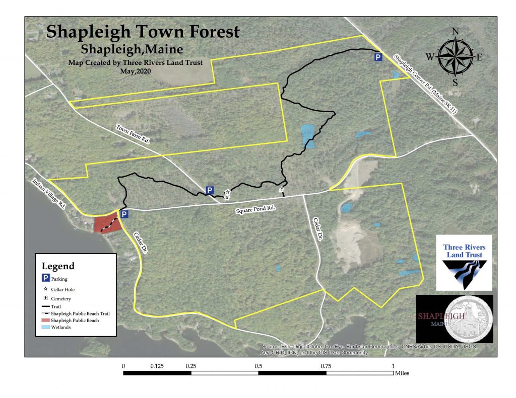
Guide to Shapleigh Town Forest Nature Trail
Route: Square Pond North to Route 11
Prepared by the Shapleigh Conservation Commission 1998, Revised 2020
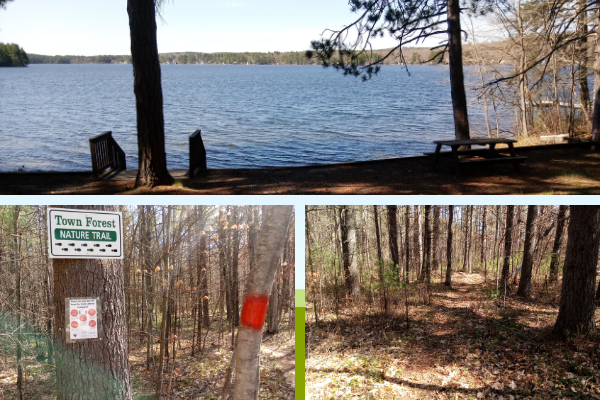
- Start from the parking lot for the Town Beach on Cedar Drive. Take the trail heading north across Square Pond Road. Walk up the hill until the Town Forest nature trail branches off to the east across what was an agricultural field in the nineteenth century. When it was abandoned, the tree seedlings least edible to livestock were the pines. Therefore, the pines got a head start and hence the field became a pine forest.
- The white pine stand was first thinned and the best trees pruned to seventeen feet about 47 years ago. It was commercially thinned for the first time by the Town Forest Trustees about 37 years ago. Ramon Day from Porter did the thinning mostly by himself but sometimes with his son. He used two pairs of oxen to haul out the logs. This section was cut again in 2018 using a timber harvester which cuts, delimbs and sections logs in one operation. Profits from this and all other harvesting endeavors are put back into the Town Forest Fund for future use by the Town Forest Trustees. Today the Town Forest is protected by a conservation easement held by Three Rivers Land Trust.
- When you reach Town Farm Road, turn to your right and walk 100 feet along the road to where the trail continues on the other side. The first item of interest you will come to is the cellar hole of what was the Boston Family Farm which became the Town Farm in 1849. A Town Farm was a place where people who had no place to live received bed and board in return for their labor. We know from the U.S. Census that in 1850 ten adults and two children lived at the farm. In 1860, there were nine plus the farmer and a governess. Of them seven were under the age of 18.
- The trail circles around the cellar hole and then passes by the barn cellar hole before heading east again through the woods. There is a stand of white pines to the north of the cellar holes which was so thickly seeded that the trees could not grow very tall. It was thinned in 1994 to enable the remaining trees to grow taller and bigger. The trees in the stand are 60 to 80 years old.
- From the homestead, the farm inhabitants had to cross a wet area to reach fields and pasture further to the east. They built a causeway or “stone bridge” over the muddy patch which allowed water to flow between the rocks and workman to bring horses and horse-drawn equipment into the fields to the east without getting stuck. The path crosses the stone bridge before turning to the right to follow an intermittent outlet stream downhill.
- The trail goes to the left but it’s worth a slight detour before continuing to visit the Boston Cemetery on the right. The trail to the cemetery crosses the stream via a wooden bridge. From here, if you wish, you can return to the parking lot by way of Square Pond Road.
- To continue on the Nature trail, return over the wooden bridge and head in a northerly direction through a section which was heavily cut in 2018. At least some of the trail in this section follows a game path through the woods.
- The trail then descends into a treeless moraine (aka a kettle hole or frost pocket) formed by the receding glaciers as they melted. When the moraine is treeless, you know there are sandy subsoils under your feet. Cool air, being denser, settles in these depressions where hard frosts are frequent into mid and late June. The trees most suited to sandy soils in this area are scrub oak, but scrub oak cannot withstand late frosts year after year when their leaves are young and tender. So, the trees die off, leaving only blueberries to carpet the sandy-moraine floor with an occasional pine.
- As the trail ascends out of the moraine, you will come to the Great Hollow Road. Before the present day route 11 was constructed in the 1920s, the Great Hollow Road connected Shapleigh Corner to North Shapleigh and beyond. At this point, you can 1) retrace your steps, 2) turn to the right and follow the road to Square Pond Road or 3) turn left and continue on the trail where it eventually ends on Route 11.
- If you choose to turn right and follow the great Hollow Road to Square Pond Road, you will pass a pool of water on your right and an interesting old stone culvert on your left. Once on Square Pond Road turn right, or west, and head back to the parking lot area.
- If you choose to turn left, follow the Great Hollow Road north for 800 feet at which point, the Nature trail continues on the right (heading east). On your left, try to find the trout brook that runs under Route 11. The trail will take you out to another moraine where it ends at route 11.